
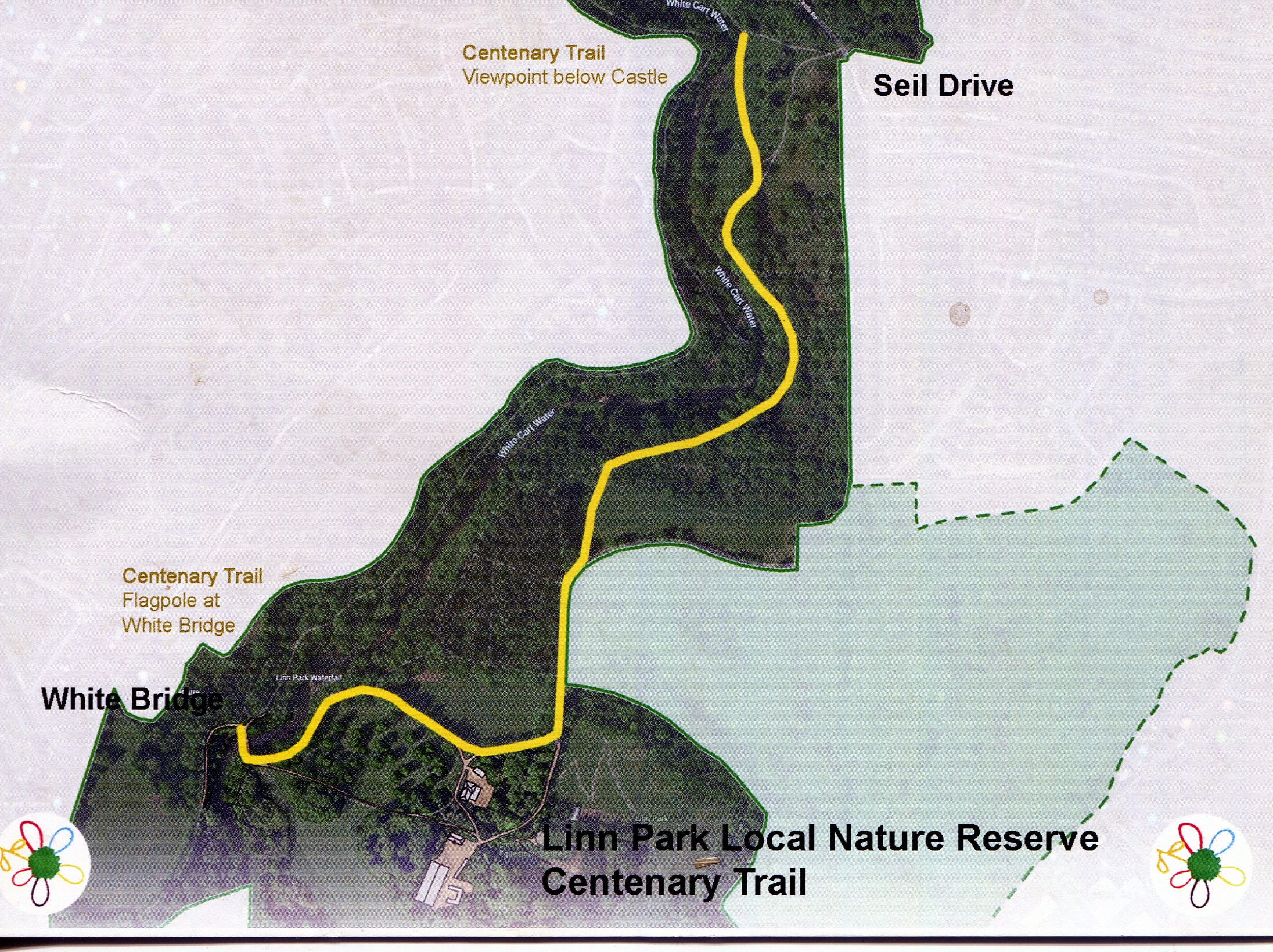
 This article records our thoughts as we wandered from the Adventure Playground along to the entrance to Linn Park, and down to the White Bridge where the "Centenary Trail" starts and thence down to the end beside the river below the Castle.
The lands forming the park have a long history, and we mention some of the features which we find interesting.
We set off along Netherlee Road. The staff at the Adventure Playground have decorated the fence. Lovely.
The field beside it which is let to the Stables and used for grazing their ponies has no grass, and they have resorted to leaving hay bales - the huge round ones - for grazing. Signs of global warming together with not harrowing the field.
The entrance to the park is magnificent, if a bit old [Photo 08]. The gates are a bit mildewed, and one of them is "tarmacced in". The old gate hitch has broken on one side.
We are reminded of Callum James Lally and the memorial bench which no longer has a view of the field.
A post is awaiting some future signage, beside the decrepit litter bin which sits between the posts of a long departed notice board.[Photo 14]
We set off down through the avenue towards the White Bridge - and suddenly are surprised by a young man who comes silently up behind us on an electric bike travelling flat out - well over 30 miles an hour anyway. And within a minute or so by two more - though they seem to be on pedal power alone and not quite so fast - but too fast to swerve.
We reach the White Bridge, and spot the first of the Centenary posts [Photo 20]. Nice photo of the White Bridge, which we understand to be a Cast Steel bridge - may be one of the first in the world [Photo 21]. The difference between Iron and Steel is simply the amount of carbon it contains.
We continue up the avenue to the view point of the waterfall [Photo 24]. On the right is a damp place - used to be a huge puddle - now drained and is best described as wild ! The bench facing the waterfall is in memory of a young man who jumped off the waterfall one hot day into the deep hole below it, and sadly drowned.
As we carry on up the hill, where there used to be a static wooden train model, on one of the avenue trees to the right is nest box 22. The centenary post is titled "Boxing Clever" and indicates that are some 60 nesting boxes. [Photo 29].
Bearing left we continue towards the pine wood, and the next Centenary post is on the corner and is entitled "The Estates of the Park".[Photos 32 & 33] If you had looked to your left just before crossing the wee culvert you would have spotted two ancient stone gate posts. In those days they were cheaper than wooden ones. Between the post and the pine tree on the corner and hidden in the bush Post No 2 of the original STAG course. The course then went up the hill to your right. There is a raft of articles about the various estates - see here.
Part way along the road is the information board on the Pine Wood, which replaced the previous one although it is mounted on the same frame [Photo 35].
We note that the path alongside the raod has been given a cover of "type 1" which is quarried waste product. Further examination shows that the path that goes direct to the river has received the same surface treatment, and the very old path leading north and then east has been restored as well. One can tell the old paths as they had stone edgings and a base of what is probably ash from the coal fires from the Mansion House. One can see the same on the path in the top wood, and several other places.
Emerging past the pine wood the route takes us down the bottom edge of the grassland [Photo 40]. Not a butterfly in sight. However, on the left are several young Rowan trees covered in berries.[Photo 42]
The next Centenary post is at the top of hill and is entitled "Meadows and Wild Flowers". It states that there are two meadows [Photo 44]. In reality a meadow is beside a river which floods and deposits silt on it. However in recent centuries the rivers have mostly been "tamed" and it has become to mean a place with wild flowers and lots of grass. A classic example is to be seen on the riverside path up to Stamperland on the other side of the river.
Just over the metal fence from the post is an old iron fence post which shows that this was once an area where sheep were bred. The post has six wire tensioners, the bottom one barely visible but the bottom three are close together to stop the lambs from going for a swim ! [Photo 45] If you look up carefully into the trees you will one tree hung on another.
Without any doubt, this a beautiful path to walk in the shade on a hot summer day. The views across the river to Millholm are obscured these days by brush, and the fence does not exactly add to the charm. [Photo 46]
A bit further one come a very interesting spot. It is not only the site of the next Centenary post, but where an old "haul road" which runs from Linnview Avenue down to the river crosses the path. The post is entitled "Butterfly Transects" [Photo 48]. A "transect" is simply a route along which butterflies are counted on a weekly basis. See here for more information. No doubt the Linn Park Transects are kept secret.
The haul road has a quite steep gradient, and to keep it passable that would mean good drains. It has the classic storm drain of centuries ago - a broad trench with a triangular cross section beside the road. Other more modern drains intersect with it - for example from the golf course club house: many may remember diesel spouting up a few yards up the haul road. Until that spillage there was always a "watering hole" for dogs which had fresh water in it. Despite the council's efforts and two plastic pipes under the path, this drain still floods across the path.
Sadly there is a fatal disease is caused by Phytophthora laterali which has killed a number of the Sawara cypress (C. pisifera) and Lawson cypress (C. lawsoniana). They are currently marked with a red X [Photo 52] [They have now been cut down]. The council were first advised in 2018 when a tree near the children's playground at Seil Drive entrance was spotted dying.
The next post just before the dead trees is entitled "Industry" and features a picture of one of the mass concrete piers for an old pipe bridge just by the Riverside Park flats [Photo 53]. However it is opposite the Mill at Millholm. See here.
The penultimate post is beside the single leaved ash and entitled "Conservation Area" and features some volunteers at work [Photo 54].
Descending to the river, marks the end if the trail and the last Centenary post entitled "Play in the Park" [Photo 56]. Near by is the information board on the castle and so on - called "Archaeology" [Photo 55].
Down past the river and so for a pint at the Old Smiddy as an end to a most enjoyable walk. Their hanging baskets deserve an award ! As does their real ale.


Apologies for the quality of the photos ... despite the best efforts of "Thumbsplus" to correct rotation and skew.
So in conclusion what do we think of the park compared to thirty years ago ? It is not what is was that is for sure. It is still a very lovely place, but getting very overgrown. Lack of planned maintenance, despite the "the published plan" which is simply not happening, and what does happen is often driven by Glasgow City Council's desire to grab any grant money going. What a waste.
A good effort by the Second Friends of Linn Park. But will their posts survive as long as those of the first STAG trail - which itself was based on the Linn Park Nature Trail.